 "zeontestpilot" (zeontestpilot)
04/22/2016 at 07:52 Ľ Filed to: Michigan
 3
3
 12
12|
"zeontestpilot" (zeontestpilot)
04/22/2016 at 07:52 Ľ Filed to: Michigan | 3
| 12 |
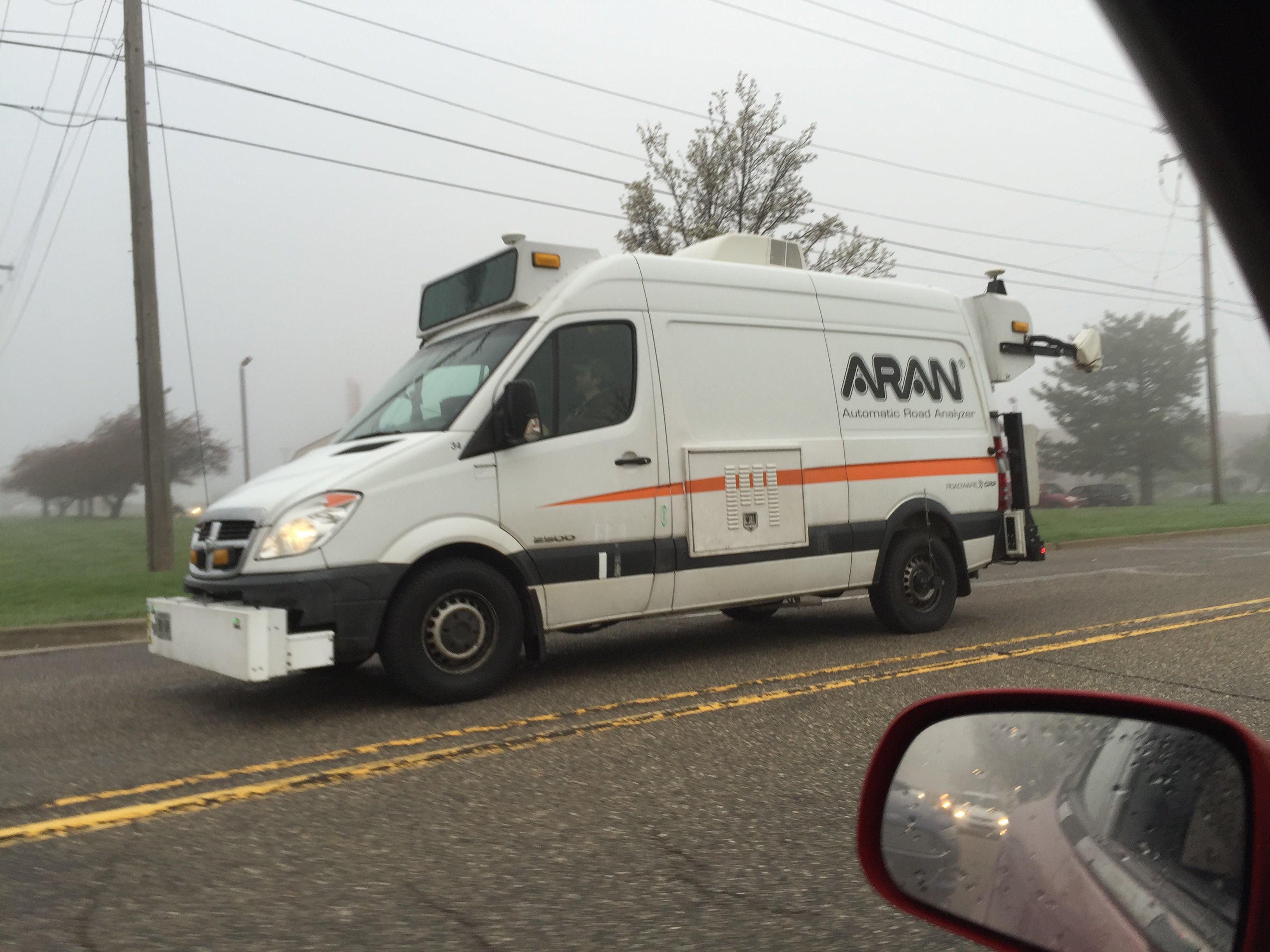
Didn't realize things like this existed, makes sense though. It's a Automatic Road Analyzer.
 Honeybunchesofgoats
> zeontestpilot
Honeybunchesofgoats
> zeontestpilot
04/22/2016 at 08:08 |
|
Pfft, big deal. My carĺs trim automatically detects the slightest imperfections in the road and emits an audible warning and that came as standard equipment.
 dogisbadob
> zeontestpilot
dogisbadob
> zeontestpilot
04/22/2016 at 08:12 |
|
inside thereĺs a big display that says THIS ROAD SUX
 AuthiCooper1300
> zeontestpilot
AuthiCooper1300
> zeontestpilot
04/22/2016 at 08:25 |
|
Many years ago (late 70s or very early 80s) Saab used to build some cars with a retractable fifth wheel (within the bodywork) to test grip in runways, particularly when very wet or in freezing conditions.
I understand that there were/are vehicles of other brands doing exactly the same, but it seems those were developed/built by Saab themselves. Bear in mind at the time there were not too many fast FWD cars around (there being no propshaft, the fifth-wheel apparatus was much easier to integrate in a FWD configuration).
|
zeontestpilot
> Honeybunchesofgoats
04/22/2016 at 08:25 |
|
This is with scientific equipment so the city canĺt deny it any more!
|
zeontestpilot
> dogisbadob
04/22/2016 at 08:27 |
|
In all caps too, and preferably in comic sans for the full effect.
 jvirgs drives a Subaru
> zeontestpilot
jvirgs drives a Subaru
> zeontestpilot
04/22/2016 at 08:34 |
|
Iĺve seen a few of these before and never knew what they were
 f86sabre
> zeontestpilot
f86sabre
> zeontestpilot
04/22/2016 at 08:38 |
|
I saw one last week as well in Atlanta. Lots of lasers. Cool stuff.
|
zeontestpilot
> AuthiCooper1300
04/22/2016 at 08:42 |
|
Huh, that's pretty cool.
|
zeontestpilot
> f86sabre
04/22/2016 at 08:45 |
|
I'm secretly hoping those lasers cut something. *pew pew*
|
AuthiCooper1300
> zeontestpilot
04/22/2016 at 08:48 |
|
This is a much, much later specimen converted by a specialist firm, but you get the idea:
http://www.sarsys.se/content/sarsysů
 TheRealBicycleBuck
> zeontestpilot
TheRealBicycleBuck
> zeontestpilot
04/22/2016 at 11:03 |
|
My company contracts with a couple of companies to perform this type of analysis. I think I can answer some of the burning questions I know you all must have!
Whatĺs going on here?
The van has video systems pointing ahead, straight down, and behind. Like google street view, technicians can review video from their desk and catalog everything they see that is wrong with the road. All of the video is tied to real-world positions via embedded GPS encoding. If a problem is spotted, its fairly easy to measure the size of the problem and get the correct location.
The van also has ground-penetrating radar (GPR). The feed is sent to a location/time stamped video system as well as a geographic information system so the location can be coded. GPR allows us to see whatĺs going on under the pavement. Physical gaps as well as transitions between materials can be seen. Iĺve seen areas where the pavement looks fine but the base material has been washed away and the road is in danger of collapsing. Iĺve also seen areas where the road surface is horrible, but the base layers are fine, so a simple surface removal and new overlay will suffice for the repair.
Some of the vans also have pavement strength testers. Itĺs basically a machine that tests the deflection of the road when a load is applied.
The company we usually work with doesnĺt use vans. Instead, they have everything mounted on a trailer.
Why do this?
While some cities have been progressive in managing their roads, the majority have not. Roads are funny things, especially when it comes to maintenance and repair. Money to manage roads is embroiled in a political process where different districts within a city are competing for dollars. Cities are beginning to realize the value of keeping good records. It helps to have an objective method for distributing funds that is based on actual road condition instead of political pull.
FEMA and FHWA are also influencing the utilization of this technology. Katrina taught these agencies that major disasters have as much impact on the transportation system as they do on buildings and people. The big trucks used to haul out debris and bring in new construction materials damage the roads, especially when the roads have been inundated with water for an extended period. FEMA and FHWA have been footing the bill for the repairs, and itĺs a big one.
The big issue is understanding how much of the damage was already there and how much was caused during and after the disaster. To solve this dilemma, FEMA and FHWA are starting to require pavement management systems which can show the condition of the roads before and after the disaster. A pavement management system can be as simple as a good map and good record-keeping, but with the newest technology, a couple of vans and a few technicians can keep track of the surface and subsurface conditions for an entire city, all in a comprehensive database that is easily accessible.
What are the limitations?
Anything that requires them to stop is left out. See a pothole? The area of the pothole can be measured from the video, but getting the correct depth canĺt. We saw some instances where a small hole is visible on the surface, but the base was washed away. A hole the size of a quarter hid a six-foot deep cavern beneath. This will show up in the GPR, but not if the cavern is full of water. Which brings us to the next limitation.
The systems work best when everything is dried out. Water can mask the boundaries between layers and make holes seem like they are filled with material supporting the road surface.
The system canĺt tell you everything. It shows boundaries between materials if they are sufficiently different, but it doesnĺt show what that material might be. To confirm the material types and calibrate the system, a series of cores must be drilled into the road. The layers within the cores are typically subjected to testing to confirm strength and integrity. Sometimes the fill materials are too loose to maintain shape within the core (think sand or small gravel) and testing will fail.
The system is also not quite one lane wide. To get full coverage with the GPR, the van must make multiple passes. If there are places where it canĺt drive, then we get no data.
How is it making a difference?
Thatĺs a two-part answer. The biggest value to us was the ability to prove there was subsurface damage in places where the road surface wasnĺt very old and didnĺt look damaged. But that was also a two-edged sword. It showed that the subsurface was fine in areas where the road surface looked like hell. All together, using this system increased the total payout from FEMA and FHWA to help with repairs after Katrina and Sandy.
The flip side is that FEMA and FHWA are holding cities to a higher standard of proof that their roads were damaged by the storm. Without a sophisticated pavement management system in place before a disaster event, itĺs going to be harder for cities to get disaster relief funding for road repairs. This will affect smaller municipalities and rural areas dis-proportionally since they are less likely to have the funding for a pavement management system in the first place.
 Just1BeforeIDie
> zeontestpilot
Just1BeforeIDie
> zeontestpilot
04/22/2016 at 14:22 |
|
There are several companies that make something similar. They generally measure road roughness, rutting, do inventories of signs, measure bridge heights, skid resistance, pavement markings, etc...
Each state or public road network owner must keep a good inventory to receive Federal funding, these are handy tools to get it done.